|
|
|
ESTONIAN (1918-1940) MAPS |
|
|
Estonian maps in scale 1:200000
Estonian maps in scale 1:200000 were published in 1933-1940 by Department of topography and hydrography of Estonian army staff (Sv.St.Topo - Hudrograafia Osakonna) in cooperation with Latvian Geodesic - Topographic Division of headquarter of Latvian army (Armijas Štāba Ģeodēzijas Topogrāfijas dala). Cooperation was agreed on a framework and the names of populated places because Latvia produced similar collection maps in scale 1:200000. Maps in scale 1:200000 produced by Estonian and Latvian staff were based on maps of period of Russian empire (Naturally, some changes were made). Maps in scale 1:200000 have trapezoid shape, the size of frame 1 deg.30' longitude and 1 deg. latitude. Longitude from Greenwich is considered.
Maps in scale 1:200000 were named by two-digital number and name of biggest population place on the sheet.
Maps were printed in color. Maps were printed in Latvia's printing-house.

Index sheet of Latvian and Estonian maps in scale 1:200000.
Source: Planheft OSTEUROPA Baltischer Raum. 1944 (thanks mapywig.org)
Using Estonian and Latvian maps in scale 1:200000 (by increasing) German topographers during WW II prepared and published set of maps over territories Estonia and Latvia "Estland Lettland 1:100000" (scale 1:100000).
|
|
Index sheet of Estonian maps in scale 1:50000, 1:42000, 1:25000. Situation in 1936, (link)
Index sheet of Estonian maps in scale 1:50000, 1:42000, 1:25000, situation in 1936.
Maps in scale 1:25000 marked in red, maps in scale 1:42000 (south-east territories of Estonia) marked in lined red, maps in scale 1:50000 marked in grey. It is interesting, till 1940 were published more maps in scale 1:50000 than marked on index sheet (see index of published 1:50000 maps, below).
|
|
Estonian maps (1920-1940) in scale 1:50000
Estonian maps in scale 1:50000 were published by Department of topography and hydrography of Estonian army staff (Sv.St.Topo - Hudrograafia Osakonna). It was planed to publish 133 maps in scale 1:50000, till 1940 was released more than half of planned maps in scale 1:50000 (according maps4u.lt it was published 71 map in scale 1:50000).
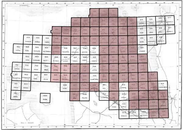 |
| Index sheet of inter-war Estonia maps in scale 1:50000, situation in 1940, digitalized maps marked in red |
Maps in scale 1:50000 have trapezoid shape, the size of frame 24' longitude and 12' latitude. Size of maps appr. 60x55 cm. Longitude from Greenwich is considered. Some maps (109, 207, 305, 307, 909) have non-typical size: of frames shown content from neighbouring maps (islands...). Maps in scale 1:50000 were named by tree-four digital number, first (or first and second) number shows row, two last numbers show position of sheet in row. Additionally maps named by name of biggest population place on the sheet.
 |
| General view of map in scale 1:50000 Nr. 312 Rakvere, 1935 |
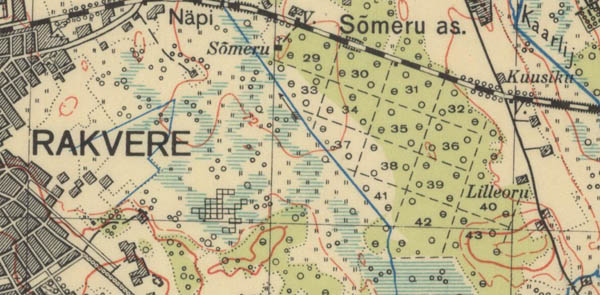 |
| Fragment of map in scale 1:50000 Nr. 312 Rakvere, 1935 |
Relief was shown by horizontals (every 8 meters). Most of maps are published in color: content in black, water in blue, forests in green, relief in brown. On frames additional information was given: name of map, administrative unit, creator, publisher, date of publishing, serialize and other information.
|
|
Estonian maps (1920-1940) in scale 1:42000
On territories of south and south-east Estonia according of Russian Empire maps in scale 1:42000 Department of topography and hydrography of Estonian army staff prepared and published maps in scale 1:42000 (see index sheet). Maps in scale 1:42000 replaced maps in scale 1:50000. Maps in scale 1:42000 have trapezoid shape, the size of frame 15' longitude and 10' latitude. Longitude from Pulkowo is considered. Maps in scale 1:42000 were named by two digital numbers; parallel was given numbering according Russian empire maps in scale 1:42000. Relief was shown by horizontals. Most of maps are published in three colors: content in black, water in blue, relief in brown.
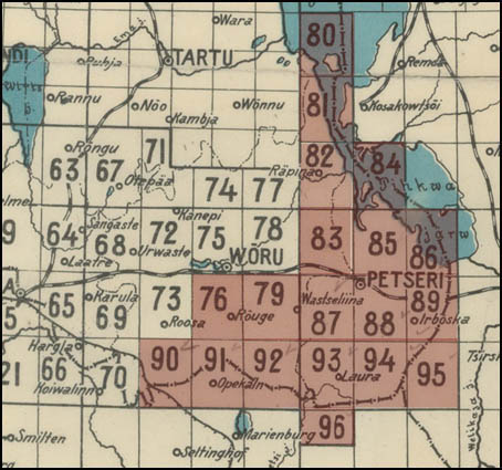
Index map showing inter-war Estinia maps in scale 1:42000
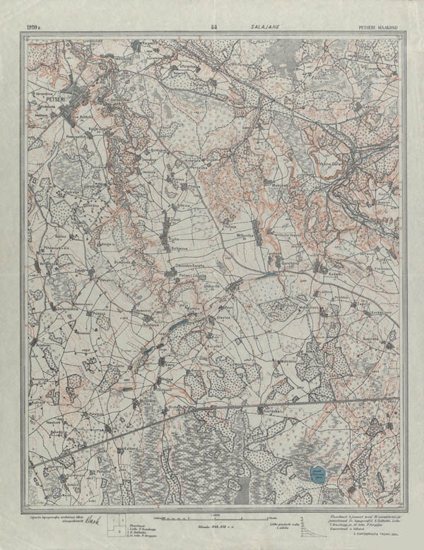
Estonian map L-88, 1:42000, 1920 (general view)
Department of topography and hydrography of Estonian army staff in earlies 1920-ies also published maps in scale 1:21000. Maps published in 2 colours - content in black, contours (relief) in brown. Size of maps - 9′ longitude x 6′ latitude (this is different as 0,5-verst maps of Russian empire), longitude was calculated from Pulkovo. All content likely transfered from 0,5-verst (1:21000) maps of Russian Empire. Some updates observed.
|
|
Estonian maps (1920-1940) in scale 1:25000
Estonian maps in scale 1:25000 were published by Department of topography and hydrography of Estonian army staff (Sv.St.Topo - Hudrograafia Osakonna). It was planed to publish about 500 maps in scale 1:25000 on territories of Estonia, till 1940 was released about 1/5 of planned maps in scale 1:25000 (acc. maps4u.lt it was published less than 100). Most of published maps covering north, north-east territories of Estonia, some maps covering the same territories as maps in scale 1:42000 (south-east territories of Estonia).
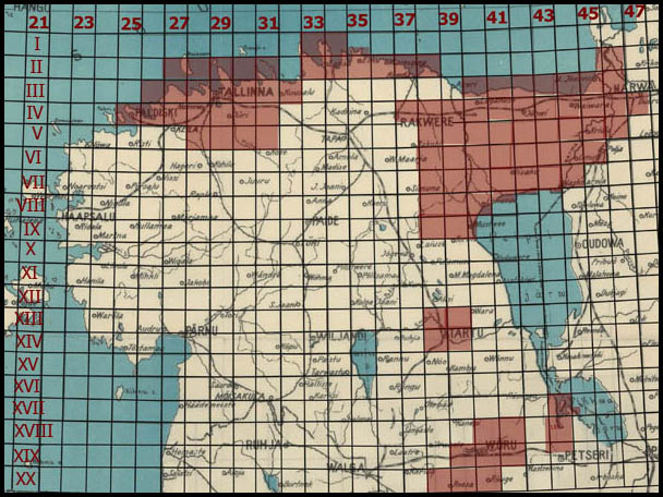 |
| Index sheet of inter-war (1918-1940) Estonian maps in scale 1:25000, maps in red are digitalized |
Maps in scale 1:25000 were named by two pair of digital numbers; first pair (Roman, I-XX) shows row, second pair (Arabic) - shows position of sheet in row. Additionally maps were named by name of maximum town on map. Alternate name of maps in scale 1:25000: maps were named as 1:50000 maps by showing S 1:25000 map position on S1:50000 map (each 1:50000 map consists of 4 S1:25000 maps), example: XVII-43 Räpina map named as 915-Ka Räpina. Maps on territories around Petseri (scale 1:25000, Petseri Laskeplatsi plaan) were named as maps in scale 1:42000 (L-85, ...). Usual size of maps in scale - 6′ latitude x 12′ longitude (dual size maps eg.: II-27-28 Naissaare - 6′ latitude x 24′ longitude or maps II, III-31 Harjumaa 12′ longitude x 12′ latitude). Non standart size maps were published on borderline territories (eg.: map VII-42 Alajõe has size 6′ latitude x 4′ longitude). Longitude on maps published till 1929-1930 was considered from Pulkovo (additionally longitude was recalculatated from Greenwich), on maps from 1929-30 longitude was considered from Greenwich. Relief was shown by horizontals (everey 2 meters, on maps on south-east territories every 4 meters, occur maps where relief shown every 4.26 m./verst system). First Estonian maps in scale 1:25000 were published in one color. Later maps in scale 1:25000 were published in color: content in black, waters in blue, relief in brown. On maps of latest edition additionally woods shown in green.
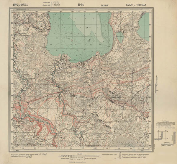 |
| General view of Estonian map in scale 1:25000 II-34 (1924, 1925) |
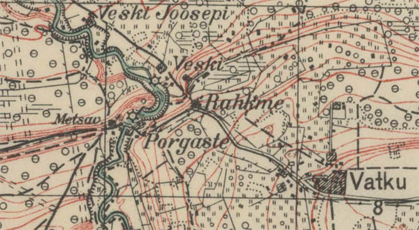 |
| Fragment of Estonian map in scale 1:25000 II-34 (1924, 1925) |
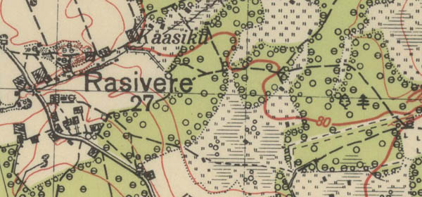 |
| Fragment of Estonian map in scale 1:25000 VI-38 Ädara (1932), woods shown in green |
During WW II German topographers using Estonian maps in scale 1:25000 prepared and published set of maps in scale 1:25000 Ostland 1:25000.
|
|
Estonian (1920-1940) cadastral maps in scale 1:10000, index sheet.
For economical purposes it was published cadastral maps in scale 1:10000. These maps covered nearly all territory of Estonia (about 1300 maps). Maps were numbered by two pair two-digital numbers. Maps were published in one color.
|
|
|
|
Not a member yet? Click here to register.
Forgotten your password? Request a new one here.
|
|

