Plans of cities (and surroundings) prepared by RKKA
On the eve and during II WW RKKA topographers prepared and published series plans of cities (and surroundings) of Russia and Europe. Plans were prepared using different cartographic material: Russian, German, Polish (...) plans of cities, serial topographical maps, it was used aerophotographing. Updated plans enable to understand growing and destroying cities.
Typical RKKA plan showing city of Europe on the eve of II WW-plan of city Warszawa, year of publishing 1932, scale 1:20000. Plan have name according 1-verst maps: LXXXIII-K Warszawa. This plan prepared using plan in scale 1:20000 published in 1924 by WIG, updated using plan in scale 1:30000 (1931-1932), schemes of development from y. 1932. All updates showed by separate colors, additional information about main institutions was given on plan.

General view of plan Warszawa, 1932, scale 1:20000
As well we manage to discover digital maps of cities:
Plan of Breslau (Wroclaw), y.1944, scale 1:15000. Plan prepared using German Messtischblatts (1936-1937), updated according newest cartographic material. On margins additional information about main military and industry institutions.
Plan if Breslau (Wroclaw), y.1945, scale 1:10000. Plan prepared using German plan of Breslau (scale 1:10000, y.1934), RKKA plan of Breslau (y.1944, scale 1:15000), aerophotographical material from y.1945.�On margins additional information about main military and industry institutions, signs.
Plan of city Lodz, scale 1:20000, one color (no y. of publishing).
Plan of city Orel (Russia), scale 1:25000, one color (no y. of publishing).
Plan of city Berlin (and surroundings), printed on 4 sheets. Scale 1:15000, year of publishing 1944, colored. Plan prepared using German Messtischblatts (1937), updated according plans:"Gross Silva Stadtplan von Berlin" (1940), "Pharus plan Berlin" (1941). On margins given topographical signs and additional information about main military and industry institutions.
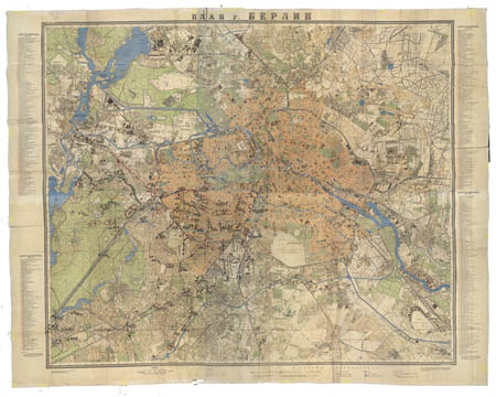
General view of plan Berlin, 1944, scale 1:15000
Plan of city Budapest, printed on 4 sheets (in collection only 2 sheets). Scale 1:25000, prepared in 1944, published in 1945 in one color. Plan prepared using Hungarian maps in scale 1:25000 (1928), updated according plan of Budapest in scale 1:25000.
Plan of city Chailar, scale 1:15000, one color. Prepared and published in 1942 using Japanese maps in scale 1:100000.